
About Waterbury Reservoir
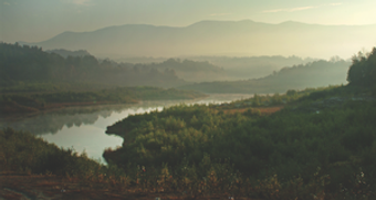
The Waterbury Reservoir is a rich ecological and recreational resource bordered by State forest lands, two State Parks, and private lands located in central Vermont in the United States. The surface water spreads an impressive 860 acres and is 6 ½ miles long from end to end. It has a maximum of 100 feet in the summertime and surrounded by 37,000 acres of the Mount Mansfield State Forest.
Waterbury Reservoir History Timeline
1800
In the early 1800's, pioneers cleared fields, rocks, and stumps in Ricker Basin and Cotton Brook. A settlement of 50 or so families once lived in this area.
1990
Since the 1990's, the Reservoir was drained twice for several years to allow for repairs and improvements to the Waterbury Dam and for bank stabilization work on the banks of Little River State Park.
2010
In 2010, the reservoir was re-filled to its normal 860 or so acres, and visitors returned in greater numbers to enjoy the large open water spaces and the Reservoir saw the return of greater numbers of loons, eagles, hawks, herons, and other wildlife.
1935
1935 and 1938, the Civilian Conservation Corps (CCC), in cooperation with the U.S. Army Corps of Engineers, constructed Waterbury Reservoir.
1994
In 1994, the Friends of Waterbury Reservoir was born of an urgent and adversarial need to confront motorboat abuse on the Reservoir, promoted not only by various motor boat advocacy groups but also by the Vermont Agency of Natural Resources. The resolution was a compromise zoning of the Reservoir, established the emergence of cooperative efforts of various motorized and quiet user’s groups.
2013
In 2013, the Friends of Waterbury Reservoir re-engaged with our partners.
Waterbury Reservoir Numbers

Waterbury Center State Park and Little River State Park have an average number of 67,280 visitors each year.
$8 million: Estimated total expenditures for durable and nondurable goods in Vermont from the two State Park visitors. (not counting non-park visitors)
Waterbury Reservoir's full water surface level is 860 acres.
From end to end the Reservoir is 6 ½ miles in length.
The maximum depth of the reservoir in the summertime is 100 feet.
589.5 feet: Water elevation in the summertime at the Waterbury Dam.
Approximately 5.5 megawatts of power generated by the Little River Hydro Station (operated by Green Mountain Power) located at the base of the Waterbury Dam.
The Waterbury dam is 1,845 feet in length and 187 feet high.
There are 5 public boat access areas to the Waterbury Reservoir. (Waterbury Dam, Blush Hill, Little River State Park, Waterbury Center State Park, and Moscow / Cottonbrook)
37,000 acres of Mount Mansfield State Forest surrounds the Reservoir.